Project 1: Decision Support With GIS
By Luminita Slevoaca
The purpose of this project is to demonstrate how GIS can be an important aid in choosing a location for a new business. Jen and Barry want to find a location to open an ice cream business. Their ideal location has to meet several business and quality of life criteria.
Business criteria:
§ to be situated in a county that has more than 500 farms for milk production
§ the town has a labor force of at least 25,000 individuals between the ages of 18 and 64 years
§ the location to be within 20 miles of an interstate
Quality of life criteria
§ a low crime index that is less than or equal to 0.02
§ at least one recreation area to be within 10 miles
§ the population of the town to be of less than 150 people/square mile
§ a location near a university or college
Initial data
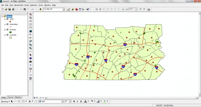
In order to perform the GIS analysis to find the best location for Jen and Barry’s ice cream business we are using the ArcMap 9.3.1 software. We have been provided with the following layers: counties, cities, interstates and recreation areas.
By Luminita Slevoaca
The purpose of this project is to demonstrate how GIS can be an important aid in choosing a location for a new business. Jen and Barry want to find a location to open an ice cream business. Their ideal location has to meet several business and quality of life criteria.
Business criteria:
§ to be situated in a county that has more than 500 farms for milk production
§ the town has a labor force of at least 25,000 individuals between the ages of 18 and 64 years
§ the location to be within 20 miles of an interstate
Quality of life criteria
§ a low crime index that is less than or equal to 0.02
§ at least one recreation area to be within 10 miles
§ the population of the town to be of less than 150 people/square mile
§ a location near a university or college
Initial data
In order to perform the GIS analysis to find the best location for Jen and Barry’s ice cream business we are using the ArcMap 9.3.1 software. We have been provided with the following layers: counties, cities, interstates and recreation areas.
Click on the image to enlarge.
Although, the polygon formed by the counties layer is a representation of the state of Pennsylvania, the features names and the data sets are fictional. The provided layers were represented initially in GCS_North American_1983 coordinate system. Since our layers are represented in the geographic system that means they are unprojected. In order to perform a better analysis on our data, we changed the coordinate system to the Pennsylvania State Plane Coordinate System, which is a Lambert Conformal Conic projection, a projection that preserves the shapes of the features while distorting their sizes.
Selecting the candidate cities
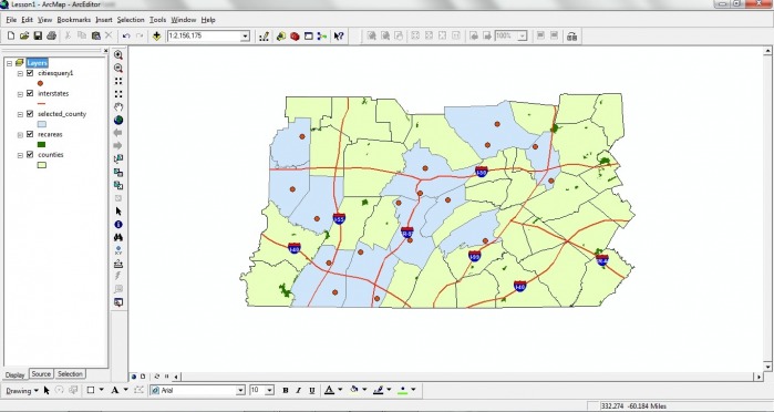
In order to meet Jen and Barry’s criteria for their ideal business location, we selected the following counties:
Once we have selected the counties that interest us, we performed a spatial query using “Select by Location” to determine the cities that are within these counties. A spatial query is the process of selecting a feature based on its location or based on the spatial relationship that it has with a different feature.
After performing these queries, the selected cities and counties are represented below.
Selecting the candidate cities
In order to meet Jen and Barry’s criteria for their ideal business location, we selected the following counties:
- that have more than 500 farms for milk production,
- have more than 25,000 individuals in their work force
- population per square mile is less than 150.
Once we have selected the counties that interest us, we performed a spatial query using “Select by Location” to determine the cities that are within these counties. A spatial query is the process of selecting a feature based on its location or based on the spatial relationship that it has with a different feature.
After performing these queries, the selected cities and counties are represented below.
Click on the image to enlarge.
The cities that are within the selected counties need to meet additional criteria.
The cities that are within the selected counties need to meet additional criteria.
- to have a university or college
- a low crime index of less than or equal to 0.02
- to be within 10 miles of a recreation area
- to be within 20 miles of an interstate
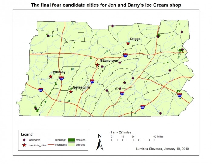
Click on the image to enlarge.
Selecting the most suitable city
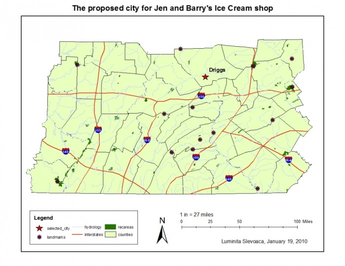
In order to select the most suitable location out of these four cities, Jen and Barry added two more criteria:
§ to be situated within 10 miles of a river or lake
§ and to be within 40 miles of a landmark
To be able to perform these additional queries, we added two new layers to our map: hydrology and landmarks. Because hydrology layer contained other features besides rivers or lakes, I extracted the rivers and lakes by performing an attribute query and exporting the data into a new shapefile. After performing two more spatial queries to find the cities that are located within 10 miles of a river or lake and 40 miles of a landmark, the city of Driggs was identified as the most suitable city.
Selecting the most suitable city
In order to select the most suitable location out of these four cities, Jen and Barry added two more criteria:
§ to be situated within 10 miles of a river or lake
§ and to be within 40 miles of a landmark
To be able to perform these additional queries, we added two new layers to our map: hydrology and landmarks. Because hydrology layer contained other features besides rivers or lakes, I extracted the rivers and lakes by performing an attribute query and exporting the data into a new shapefile. After performing two more spatial queries to find the cities that are located within 10 miles of a river or lake and 40 miles of a landmark, the city of Driggs was identified as the most suitable city.
Click on the image to enlarge.
To verify that our analysis is correct, we can verify the attribute table for the city of Driggs. The city of Driggs has a population of 17,580, has a university and a crime index of 0.016. Driggs is situated in Bellows County that has 847 milk producing farms, a work pool of 71,214 and a population per square mile of 96. I performed spatial queries and confirmed that Driggs is situated within 10 miles of the West Branch of the Susquehanna River and within 40 miles of two landmarks. I also verified that Driggs is situated within 20 miles of I-50 interstate and has one recreation area within 10 miles.
Even though our analysis identified Driggs as Jen and Barry’s ideal location to open their ice cream shop, they might want to consider other factors in performing the queries. Other important factors that I suggest to be accounted for would be average price of land per acre in a county, or if they plan to rent their business site, the average price to rent per square feet and space availability. Bellows County has 847 milk producing farms but can have distributors already for their milk, or use it for derived products themselves. Another thing to consider would be how many of these farms produce organic milk if they want to have organic products. The average income of the city’s population could also be a good indicator of their potential customers.
Applying a GIS analysis, Jen and Barry were able to find their ideal location for their ice cream business, which meets all their criteria. This project demonstrated that GIS is a powerful tool for analysis that needs to perform not just attribute but also spatial queries.
Source
King, B., & Zeiders, M. (2009). Problem-Solving with GIS, Lesson 1, Introduction/ Part I/ Part II. The Pennsylvania State University, World Campus. Retrieved January 20, 2010.
