Project 1 - Plotting Coordinates and Projections
by Luminita Slevoaca
Las Vegas, Nevada
For my first project assignment I chose Las Vegas, my adopted hometown for the past 5 years to exemplify the concept of projections and coordinate systems . When you say Las Vegas, most people will think of the cliche image of the "Strip", the street where all the casinos are. I still meet people that are surprised to see that Las Vegas is an actual city with neighborhoods, schools, hospitals and everything else.


Pictures by Luminita Slevoaca
Map Projection. Transverse Mercator
If you are new to GIS like me, you might ask yourself what is a map projection? A map projection is a transformation of the Earth’s three-dimensional surface into a flat surface with the help of complex mathematical equations. According to DiBiase(2009), there are “three types of “flattenable” surfaces to which a graticule can be projected: a plane, a cone, and a cylinder. ”
The image below helps to visualize the concept better.
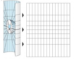
Transformation of geographical coordinates into a 2D surface. Image by University of Nebraska. Reproduced here for educational purpose only.
Why do we need several types of map projections?
A projection needs to represent accurately the Earth’s surface in terms of shape, area, distance, direction(Indiana Geographic Information Council,http://www.igic.org/standards/projections.html).
All projections induce a certain type of distortion for the features represented on the map. Since all map projections have advantages and disadvantages, before choosing one of them the mapmaker needs to decide on the purpose of his map and what property of the features needs to have a minimum distortion.
What is a Transverse Mercator projection?
The Transverse Mercator projection is a variant of the Mercator projection.
The Mercator projection is cylindrical and tangent with the Earth’s surface at the Equator. One disadvantage of the Mercator projection is that the distortion increases as we get further from the Equator. In other words, the countries close to the Equator are represented accurately but the more we move towards the poles the size of the countries increases, so they are more distorted.
For Transverse Mercator, the projection cylinder is rotated 90 degrees and is tangent with a line of longitude. The distortion will be minimal along the line of longitude chosen, also called the central meridian of the map, and increase with distance from that line.


Mercator Projection. Transverse Mercator Projection. Images by University of Nebraska. Reproduced here for educational purpose only.
Why did I choose Transverse Mercator for my projection?
- Transverse Mercator is a highly used projection in GIS.
- Transverse Mercator “serves as the basis of the global UTM plane coordinate system, the UK and proposed US National Grids, and many zones in the US State Plane Coordinate system”(DiBiase,2009).
- The state of Nevada has a north-south orientation and the State Plane Coordinates (SPC) are based on the Transverse Mercator projection.
Transverse Mercator projection of Las Vegas, Nevada
Latitude: 36º 10’ 30” N (36.175 in decimal degrees), Longitude: 115º 08’ 14” W (- 115.1372 in decimal degrees)
Central Meridian: - 115.0
Latitude: 36º 10’ 30” N (36.175 in decimal degrees), Longitude: 115º 08’ 14” W (- 115.1372 in decimal degrees)
Central Meridian: - 115.0
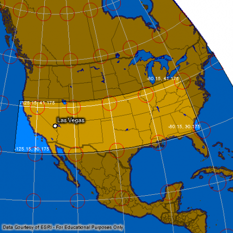
Transverse Mercator Projection of Las Vegas, Nevada. Map created using Penn State University's Interactive Album of Map Projections.( http://projections.mgis.psu.edu/)
The above image shows us that the Transverse Mercator is a conformal projection, "which means that angles plotted in the coordinate system are equal to angles measured on the surface of the Earth" (DiBiase, 2009). We can also notice that the distortion ellipses preserve their shape in this projection but their sizes increase the further we get from the central meridian, here set at -115.0 longitude. Conformal projections are useful to represent small areas, but will produce a great distortion for large areas such as continents (ESRI, Introduction to Map Design, 1996).
Geographic Coordinates
The geographic coordinates of Las Vegas, Nevada are:
Latitude: 36º 10’ 30” N, Longitude: 115º 08’ 14” W
Most people learn early in school about the geographic coordinate system. What is a geographic coordinate system? It is a reference system that helps us locate any location on the Earth’s surface with help of longitude and latitude coordinates.
What is longitude?
A line of longitude (also referred as a meridian) is a line that runs north-south forming concentric circles around the earth that intersect at the poles. The values for the lines of longitude can be between -180º to 180 º from the central meridian. The central meridian corresponds to 0º of longitude and by international convention passes through Greenwich, UK.
What is latitude?
A line of latitude (also referred to as a parallel) runs parallel and equidistant with the Equator. Latitude lines also form concentric circles and their diameter decreases forming a point at the poles. The values for latitude lines range from 90º at the North Pole to -90º at the South Pole with the Equator located at 0º.


Copyright www.pbs.org. Reproduced here for educational purpose only.
Why are latitude and longitude coordinates expressed in degrees rather than distance units?
Ellipsoids are commonly used to simplify the transformations of the Earth’s shape to a coordinate system grid. (DiBiase, 2009).
From the above representation we can see that that geographic coordinates are angular measurements. “Longitude specifies positions east and west as the angle between the prime meridian and a second meridian that intersects the point of interest. Latitude specifies positions north and south in terms of the angle subtended at the center of the Earth between two imaginary lines, one that intersects the equatorand another that intersects the point of interest” (DiBiase, 2009).
Who invented the geographic coordinate system?
Hipparchus of Rhodes (190BC – 120 BC) is attributed with the invention of a world-wide referencing system that is able to specify the location of any point on the Earth’s surface with longitude and latitude coordinates.
Why the need for different coordinate systems? What are datums?
If Hipparchus invented a system that helps us locate any point on the Earth’s surface why are there so many coordinate systems in use today? Because latitude and longitude are expressed in angles, measuring distances on a map would involve the use of trigonometry formulas that use the value of the sphere’s radius. Since the Earth is not a perfect a sphere, the radius is not constant and the calculations will be very complicated.
In order to simplify these calculations and make the maps useful, the Earth’s surface is aligned with a coordinate system grid. “The geometric relationship between a coordinate system grid and the Earth’s surface” is defined as a horizontal datum (DiBiase, 2009).
A datum can be thought of as a reference or “’starting points’ from where all measurements are taken” (Dean,2009).
There are global datums that attempt to minimize distortion on a worldwide scale. WGS 84 is one such global datum, which is an Earth-centered ellipsoid that the Global Positioning System (GPS) is based on.
Local datums, like NAD 27 and NAD 83 created for the North America, try to fit the Earth’s surface for a particular area.
The North American Datum of 1927 (NAD 27) is aligned with the Clarke Ellipsoid of 1866, an ellipsoid that was created by manually surveying the entire continent. The NAD 27 point of origin is established in Meades Ranch, Kansas.
The North American Datum of 1983 is based on the GRS80 ellipsoid, which has its origin defined as the Earth's center of mass and provides a more accurate location of points in a global context (Wikipedia - North American Datum). NAD 83 will provide different coordinates for the same point location than NAD 27 because the two datums refer to different ellipsoids.

Datum alignments. Copyright IBM - DB2 Universal Database. Reproduced here for educational purpose only.
Due to different types of datums, map projections and reference systems, we need to use several coordinate systems in order to achieve more accurate information from the maps we use.
What is a UTM Coordinate System?
The UTM coordinates (NAD83) of my Las Vegas, NV are:
Easting: 667525.054 meters, Northing: 4004966.535 meters, Zone: 11N
The process of converting latitude, longitude coordinates in UTM coordinates involves complicated trigonometry equations. I obtained the UTM coordinate values using a conversion tool from National Geodetic Survey Website- http://www.ngs.noaa.gov/TOOLS/utm.html.
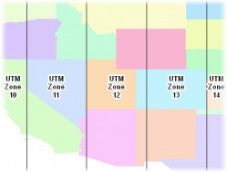
The UTM zone 11 for Nevada.Copyright UNLV.Reproduced here for educational purpose only
The Universal Transverse Mercator Coordinate System is based on the Transverse Mercator Projection and divides the Earth’s surface in 60 zones covering the whole surface between the latitudes 80º S and 84º N. Each UTM zone is 6º of longitude wide, with a central meridian situated in the center of the zone. Zone 1 starts at 180º W and spans to 174º W. Las Vegas is situated in zone 11. Each zone is divided into north and south at the Equator. For example, zone 35N corresponds to Romania and zone 35 S to South Africa. In order to provide only positive coordinates, the north zones and the south zones have their origins placed 500,000 meters west of the central meridian. Because the origins are placed outside the zone they are also known as “false” origins. (DiBiase,2009).
Each zone of the UTM system has two standard lines that are parallel and 180,000 meters west and east from the central meridian. One advantage of the UTM system is that it provides small distortion, the highest error will be 1:2,500 at the central meridian and 1:1000 inside the zones. (DiBiase,2009).
UTM is a conformal projection, meaning that the features on the map will maintain their shape but their sizes will be distorted.(DiBiase,2009). UTM coordinates are expressed in meters rather than in degrees to simplify the calculations of small distances between two points.
State Plane Coordinates
The State Plane Coordinates (NAD83) of Las Vegas, NV are:
Easting: 240130.079 meters, Northing: 8158178.855 meters, Zone: 2701 North East.
I obtained the SPC coordinate values using a conversion tool from National Geodetic Survey Website - http://www.ngs.noaa.gov/TOOLS/spc.shtml.
State Plane Coordinate (SPC) is a coordinate system developed for the United States that divides all 50 states into 124 zones. State Plane Coordinate was created in 1930 by the U.S. Coast and Geodetic Survey and was referenced upon the North American Datum of 1927. The main goal was to create a map projection that assumes that the Earth is flat for a particular state and the maximum distortion scale was 1:10,000, considered at the time the limit of surveying accuracy. (MARIS, 2009) When a map covers a small area, a SPC system is preferred over a UTM system because it provides 4 times better accuracy (UTM maximum distortion error is 1:2,500).
In order to keep the distortion error low most states are divided into several zones, with the exception of smaller states like Connecticut that are covered only by one zone. Unlike UTM zones that are delimited by lines of longitude, SPC zones are delimited by political boundaries, which make them more practical to use in GIS applications. SPC zones use a Transverse Mercator or a Lambert Conic Conformal projection, the only exception being one of Alaska’s zones that uses an Oblique Mercator projection. “Wide” zones like Pennsylvania that have a greater west-east extend are based on Lambert Conic Conformal projection and ‘’tall” zones like Idaho that have a greater north-south extend are based on Transverse Mercator projection (DiBiase, 2009). Coordinates in a state plane zone are expressed as eastings and northings and like the UTM system the origin is placed 200,000 to 800,000 meters west of the central meridian of the zone in order for the coordinates to be positive values (DiBiase,2009).
Nevada is a “tall” state, based on a Transverse Mercator projection and it is divided into 3 zones: West, Central and East. Las Vegas is located in the Nevada East zone.
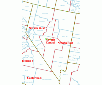
Nevada's State Plane zones. Copyright Colorado State University. Reproduced here for educational purpose only
The first developed State Plane Coordinate System, also known as SPCS 27 was based on NAD 27 and Clarke 1866 ellipsoid. After the adoption of NAD 83 and GRS80, the SPC system needed to be updated to account for the changes produced by the shifting of the point of origin from Meades Ranch, KS to Earth’s center of mass. This update resulted in the creation of the State Plane Coordinate System of 1983 (SPCS 83). For obvious reasons, point locations defined using SPCS 27 will have different coordinate values than if they were defined in SPCS 83. The update was necessary for several reasons: to have compatibility with modern satellite systems, some states changed the boundary of their zones and the values of longitude and latitude are slightly different (MARIS,2009).
Comparison
The Earth’s surface is approximated to the size of an ellipsoid. A map projection is the transformation of the Earth’s spherical shape into a flat surface and since we are converting a 3D surface to a 2D surface certain areas will suffer a distortion. There are a variety of projections and all of them will produce a distortion. The best projection for a map is the projection that minimizes the distortion for a particular area of interest.
The Geographic Coordinate System is useful when we view the Earth as a sphere and helps us visualize our defined locations in a global context. The Geographic Coordinate System does not require a projection and is useful if the area of interest for our map covers several UTM or SPC zones. One disadvantage is that the coordinates are expressed in angular measurements and that makes it difficult to measure distances between two points.
The UTM Coordinate System covers almost the whole globe, with the exception of small surface close to the Poles. The UTM system presents many advantages like a constant distance relationship on a map. Another advantage is that the coordinate values are positive numbers and are expressed in meters making it easier to calculate distances. Since UTM zones are defined by lines of longitude and not political boundaries like SPC zones it can make map analysis difficult for areas that spread across zones. Another reason why this type of analysis it is difficult, is because the UTM system does not provide a mathematical relationship between the coordinates of two adjacent zones.
State Plane Coordinate System was created for United States. Each state has a Transverse Mercator or a Lambert Conic Conformal projection based on the state’s shape. The SPC system provides better accuracy than the UTM system. The coordinate values are positive number and measured in feet in SPCS 27 and meters in SPCS 83. One disadvantage of SPC system is that it might produce errors at the boundary of the zones.
Sources
David DiBiase – The Nature of Geographic Information (2009) - https://www.e-education.psu.edu/natureofgeoinfo/
National Geodetic Survey (no date) NADCON - North American Datum Conversion Utility. Retrieved October 25, 2009, from http://www.ngs.noaa.gov/TOOLS/Nadcon/Nadcon.html
National Geodetic Survey (2004). SPC Utilities. Retrieved October 25, 2009, from http://www.ngs.noaa.gov/TOOLS/spc.html
National Geodetic Survey (2004). UTM Utilities. Retrieved October 25, 2009, from http://www.ngs.noaa.gov/TOOLS/utm.html
Penn State Online GIS Education (2005). Interactive Album of Map Projections. Retrieved October 22, 2009, from http://projections.mgis.psu.edu
United States Geological Survey (2006). Geographic Names Information System. Retrieved October 22, 2009, from http://geonames.usgs.gov
Denis J. Dean, Colorado State University - Retrieved October 23, 2009 -http://warnercnr.colostate.edu/class_info/nr502/lg3/lg3_master.html
MARIS – Mississippi Automated Resource Information System - Retrieved October 23, 2009 -http://www.maris.state.ms.us/Htm/Other/StatePlane.html
MAP PROJECTIONS - Vicki Chmill, University of California, Santa Barbara - Retrieved October 27, 2009 -http://www.geog.ubc.ca/courses/klink/gis.notes/ncgia/u27.html
Coordinate Systems Overview, P.H. Dana - Retrieved October 24, 2009 - http://www.colorado.edu/geography/gcraft/notes/coordsys/coordsys_f.html
An Overview of Geodesy and Geographic Referencing Systems - Retrieved October 22, 2009- http://www.gsd.harvard.edu/gis/manual/projections/fundamentals/
University of Texas at San Antonio, Laboratory for Remote Sensing and Geoinformatics –
Ellipsoid and Datum, Projection, Coordinate system, and Map Scale: Ellipsoid and Datum, Projection, Coordinate system, and Map Scale Lectures 4 and 5 Feb. 2 and 4, 200 - Retrieved October 24, 2009
http://www.utsa.edu/lrsg/Teaching/ES2113/L4_projection.pdf
IBM DB2 Universal Database - Retrieved October 24, 2009- http://publib.boulder.ibm.com/infocenter/db2luw/v8/index.jsp?topic=/com.ibm.db2.udb.doc/opt/csb3022a.htm
Indiana Geographic Information Council- Retrieved October 22, 2009 - http://www.igic.org/standards/projections.html
Figure Nevada’s UTM zone- Retrieved October 25, 2009 - http://faculty.unlv.edu/jensen
Wikipedia – North American Datum - Retrieved October 23, 2009 http://en.wikipedia.org/wiki/North_American_Datum
Wikipedia - Prime Meridian - Retrieved October 23, 2009-http://en.wikipedia.org/wiki/Prime_Meridian
Hipparchus of Rhodes Biography - Retrieved October 22, 2009 - http://www-gap.dcs.stand.ac.uk/~history/Biographies/Hipparchus.html
Peterson, 2009 - Retrieved October 22, 2009 - http://maps.unomaha.edu/Peterson/gis/notes/MapProjCoord.html
Page updated November 10, 2009
