Project 2: Creating and Interpreting Maps
By Luminita Slevoaca
Las Vegas, Clark County, Nevada
The purpose of Project 2 is to create a reference and a thematic map using U.S. Census Bureau’s American FactFinder (AFF) application. I chose to make a representation of my current neighborhood situated in Las Vegas, NV
Introduction
The purpose of the U.S. Census Bureau is to collect statistical data about the population and also to make it available for various analysis.AFF is an online mapping software developed by the Census Bureau that creates reference or thematic maps using vector data extracted from the TIGER (Topologically Integrated Geographic Encoding and Referencing) database. The census data is not contained in the TIGER/Line files but is associated with its geometry though the address range attribute. Since the TIGER database is not copyrighted, it represents a data source for many commercial applications. (DiBiase, 2009,Chapter 4,TIGER, Topology and Geocoding.)
Reference Map.
 |  Las Vegas, NV. Map created using the U.S. Census Bureau's American FactFinder Reference Map Application |
The above figure was created using the U.S. Census Bureau’s AFF Reference Map application and it depicts my current neighborhood, located in West Las Vegas, Clark County, Nevada. The features represented in my reference map are listed in the legend next to the map and include major roads and streets, railroads, water streams and political boundaries. My map covers approximately 7 miles across and at this scale we can see the main streets that outline my neighborhood. Zoomed in at 1.1 miles across, the street that my house is located on and adjacent streets are partially represented. A possible explanation would be that my neighborhood was build in 2005 and the 2008 Population Estimates dataset that I used to generate my map is not intended to be complete and it contains only the information that is useful to enumerators to orient themselves when locating addresses (Sloan, personal communication, Fall 2009).
According to DiBiase(2009, Chapter 2, Scales and Transformations), “map scale is the proportion between a distance on a map and a corresponding distance on the ground”. In order to calculate the scale we need the width of the image. I opened the GIF image in Paint, a standard application on a Windows platform, and checked the Attribute properties that list the width of the image to be 5.99 inches at a resolution of 96 DPI. The width of the image will appear smaller or larger when it is viewed at a different resolution. First, I made the transformation from miles to inches (7 miles= 443,520 inches) and calculate my scale to be 443,520"/ 5.99"= 74,043". From my calculation, I deduce that the scale of my map as a representative fraction is 1:74,000 or 1" on the map equals 1.17 miles.
According to DiBiase(2009, Chapter 2, Scales and Transformations), “map scale is the proportion between a distance on a map and a corresponding distance on the ground”. In order to calculate the scale we need the width of the image. I opened the GIF image in Paint, a standard application on a Windows platform, and checked the Attribute properties that list the width of the image to be 5.99 inches at a resolution of 96 DPI. The width of the image will appear smaller or larger when it is viewed at a different resolution. First, I made the transformation from miles to inches (7 miles= 443,520 inches) and calculate my scale to be 443,520"/ 5.99"= 74,043". From my calculation, I deduce that the scale of my map as a representative fraction is 1:74,000 or 1" on the map equals 1.17 miles.
Thematic Map.
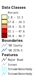 |  Percent of Occupied Housing Units that are Renter-Occupied in 2000, Las Vegas, NV. Map created using the U.S. Census Bureau's American FactFinder Thematic Map Application |
The above map was created using the Census Bureau’s AFF Thematic Map application and it represents the percent of occupied housing units that are renter-occupied in Las Vegas, NV based on Census 2000 Summary File 1, 100 – Percent Data. The Census 2000 data is formed from the Summary File 1 (SF 1) that contains 100% data, questions asked of all households and the Summary File 3 (SF 3) that contains sample data that is estimated from the detailed questionnaires filled out by a part of the households.(DiBiase, 2009a, Chapter 3, Census Data and Thematic Maps)
To calculate the scale for my thematic map I used the same technique as my reference map. The width of my map is 5.99 inches at a resolution of 96DPI and covers an area of approximately 20 miles (1,267,200 inches). Applying the formula that the distance on the map is equal to the distance on the ground, it results in a scale fraction of 1,267,200"/ 5.99" = 211,552". This means that the map scale as a representative fraction is 1:211,000 and 1" on the map equals 3.34 miles on ground.
To analyze the percent of renter-occupied houses in Clark County, NV, I used a 5 – Digit ZIP code geography delimitation and centered the map on my current zip code 89139. From the legend, situated on the left of the map we understand that the zip codes represented in lighter shades have a lower percentage of renter-occupied houses, while darker shades have a higher percentage. Maps that use graduate color shades to represent attribute data values are called choropleth maps. (DiBiase,2009b, Chapter 3, Census Data and Thematic Maps)
The data representing the percent of renter-occupied houses is divided into five classes after a quantile classification, meaning that each class has an equal number of features. I chose the quatnile classification for my map because it has the advantage of creating distinct patterns to display the data. Looking at the above map, we can easily notice that the zip codes along interstate I-15 and Las Vegas Blvd., which is the commercial and the tourism area of the town, have the highest percent of rented houses. Based on local knowledge, further we get from Las Vegas Blvd., there will be family oriented neighborhoods followed by rural areas. The family oriented neighborhoods and rural areas translate into lower percentages of renter-occupied houses represented by lighter shades of color on the map. The pattern of renter-occupied houses displayed in my thematic map sustains my field observations.
AFF makes the data used for creating the thematic map available for download in an Excel or Txt format. From this table I noticed that my zip code, 89139 is in class 1 and has 5.1% of renter-occupied houses but also a small number of houses, only 816. Since the 2000 Census, the data set that I used to generate this map, the city extended towards the southwest and on mere observation, I think my neighborhood will have a high percent of renter occupied houses after the 2010 Census.
Using the Fact Sheet application from AFF, I notice that Clark County has a high rate of 40.9 % renter-occupied houses compared to the national rate of 33.8%, based on the 2000 Census, Summary File 1 (SF 1) and Summary File 3 (SF 3). According to the latest data set from the U.S. Census Bureau, 2008 American Community Survey, Clark County maintains a high rate of 40.3% renter occupied houses. The high rate can be explained by the fact that Las Vegas was one of the fastest growing cities in U.S. for the past 10 years. The population growth led to a construction boom that made Las Vegas a transient town for many workers.
Summary
AFF is an online mapping software that provides free of charge access to the U.S. Census Bureau’s statistical and geographic data. AFF provides tools to create thematic and reference maps. The information provided by these type of maps it is versatile and when used correctly certain patterns needed for various type of analysis will emerge.
AFF is an online mapping software that provides free of charge access to the U.S. Census Bureau’s statistical and geographic data. AFF provides tools to create thematic and reference maps. The information provided by these type of maps it is versatile and when used correctly certain patterns needed for various type of analysis will emerge.
Sources
DiBiase, David (2009). The Nature of Geographic Information, Chapter 2, Scales and Transformations, Section 5 – Map and Photo Scale. Retrieved November 16, 2009
DiBiase, David (2009a). The Nature of Geographic Information, Chapter 3, Census Data and Thematic Maps,Section 4 – Enumerations versus Samples. Retrieved November 17, 2009
DiBiase, David (2009b). The Nature of Geographic Information, Chapter 3, Census Data and Thematic Maps, Section 16 – Mapping Rates and Densities. Retrieved November 18, 2009
DiBiase, David (2009). The Nature of Geographic Information, Chapter 4, TIGER, Topology and Geocoding, Section 3 – TIGER and MAF. Retrieved November 16, 2009
U.S. Bureau of the Census (2003). American FactFinder. Retrieved November 16, 2009, from http://factfinder.census.gov
Page updated December 15, 2009
